AI systems & automation · remote sensing

Waseem
Hanif.

I build AI systems that run without supervision. Pipelines that generate video end to end, agents that answer and book, factories that turn long footage into finished clips. Built to survive absence, with retries, approval gates and audit trails.

LinkedIn
Muhammad Waseem Hanif

Muhammad Waseem Hanif

Lahore, Pakistan

Largest pipeline
61nodes, 5 vendors
Agent tools
8live, not simulated
Thesis grade
4.0distinction
Based in
PKremote, worldwide

What I do

01

AI agents & pipelines

  • Tool-calling agents with retrieval, memory and real actions
  • Multi-model orchestration, each step routed to the right model
  • Fallback routing so one dead endpoint cannot stop a run
02

Generative video

  • Script to scene to clip to assembled video, automated
  • Lip-synced presenters and synthesised voice
  • Clip factories producing short form at volume
03

Unattended operation

  • Scheduled runs that retry, wait for network and self-heal
  • Human approval gates where publishing wrong would cost
  • Audit trails, so a decision can be checked afterwards
04

Satellite & GIS

  • Vegetation indices and quantified change detection
  • Land cover classification with accuracy assessment
  • Print-ready layouts, or raw GeoTIFF

AI systems

Things that keep running
when I am not there.

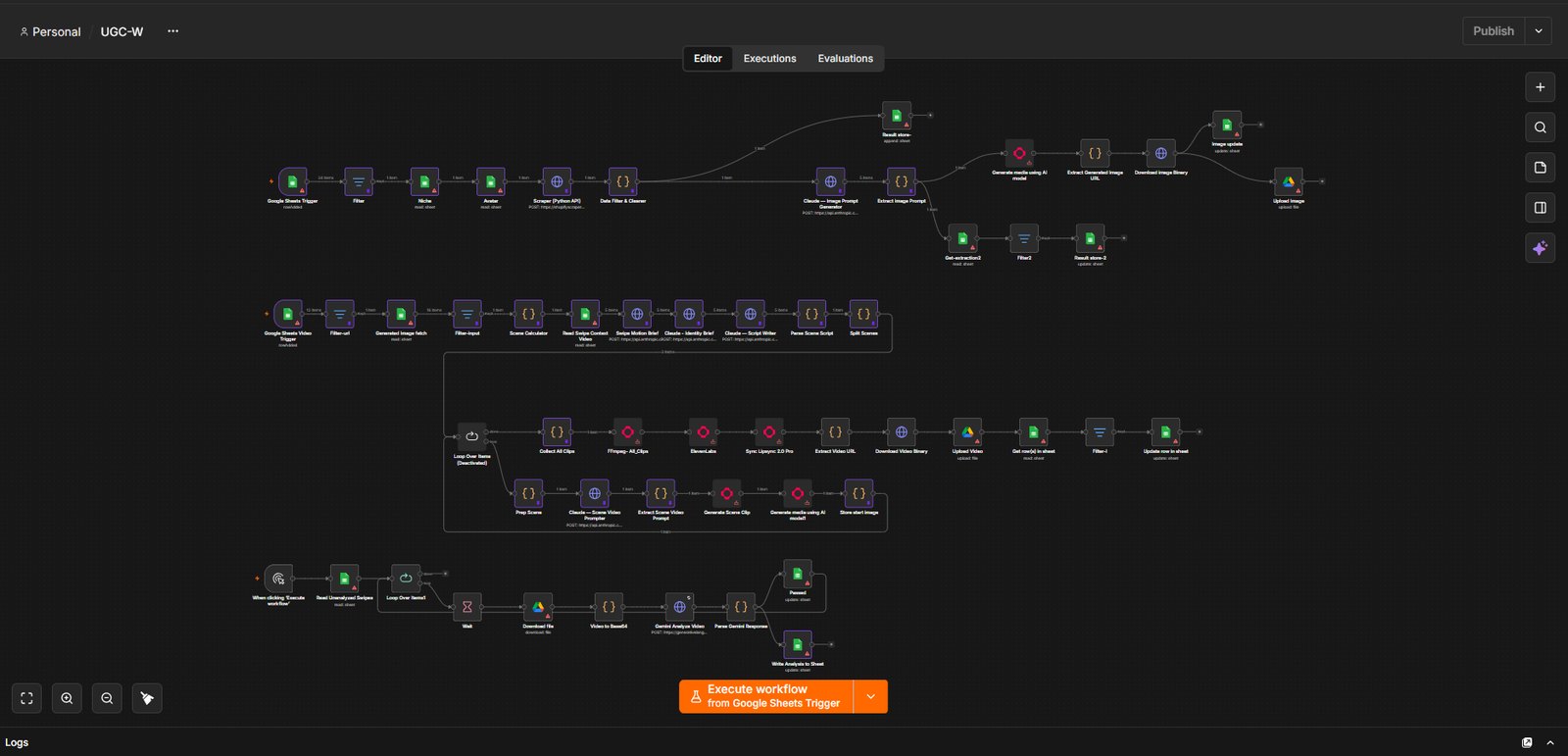
The UGC-W workflow canvas in n8n: parallel branches of nodes covering scraping, Claude prompt generation, scene splitting, clip generation, lip-sync and assembly
GRQ Holdings · 2026

Head of AI infrastructure

61 nodes from a product URL to a finished video ad

One link in, a complete advert out, with a lip-synced presenter reading a script written for that exact product. Each model is picked for what it does best: Claude for creative direction, Gemini to watch the generated footage back and judge it, fal.ai for imagery and motion, ElevenLabs for voice.

The hard part was never generation, it was keeping sixty-one steps coherent. Eighteen code nodes carry the logic that splits scenes, bridges them so the cuts make sense, and recovers the right asset URL from each vendor response.

Nodes
61
Logic steps
18
Vendors
5

n8n · Claude · Gemini · fal.ai · ElevenLabs · Sync Labs · FFmpeg · Sheets and Drive

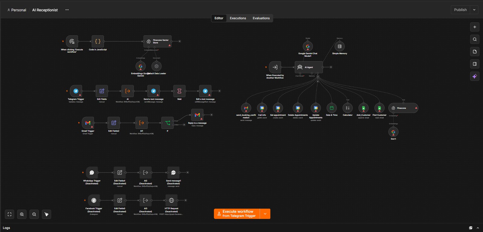
The receptionist workflow canvas in n8n: an AI agent with eight tools fanning out to calendar, CRM and confirmation actions, beside a Telegram intake flow with a wait and edit step

AI receptionist

An agent that actually books, not one that promises to

Most chatbot demos stop at conversation. The fan of tools on the right of that canvas is the difference: live calendar reads, appointment create, update and delete, a CRM lookup and append, and a confirmation it sends itself. Retrieval over the real service documents keeps its answers specific rather than generic.

The small chain on the left is the detail that makes it feel human. People send three short messages in a row, so it waits, flushes them together, and edits one reply into place instead of interrupting itself twice.

Tools
8
Channels
3
Sub-flows
7

n8n · Gemini · Pinecone · Google Calendar · Sheets CRM · WhatsApp · Telegram

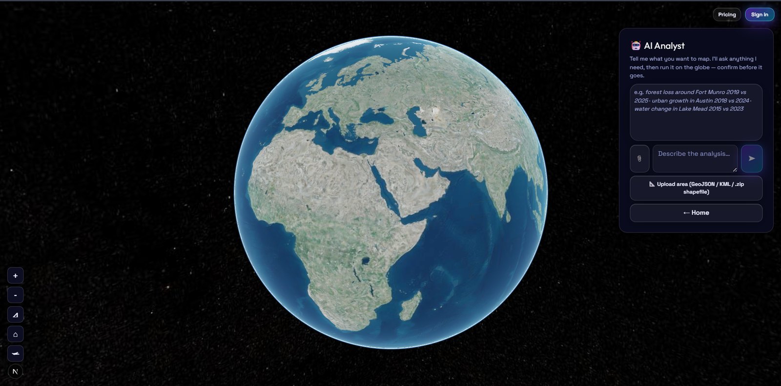
GeoReport AI Analyst panel beside the globe, inviting a plain-language description of the analysis to run
Live

GeoReport AI · conversational analyst

Describe it in a sentence, confirm before it runs

Say what you want mapped in plain language and it interviews you for whatever it still needs, proposes candidates when a place name is ambiguous, then shows exactly what it is about to run and waits.

That confirm step matters because every run costs real satellite processing time. Guessing at a vague request and mapping the wrong area is the expensive failure.

FastAPI · multi-turn agent · geocoding with candidate fallback · CesiumJS

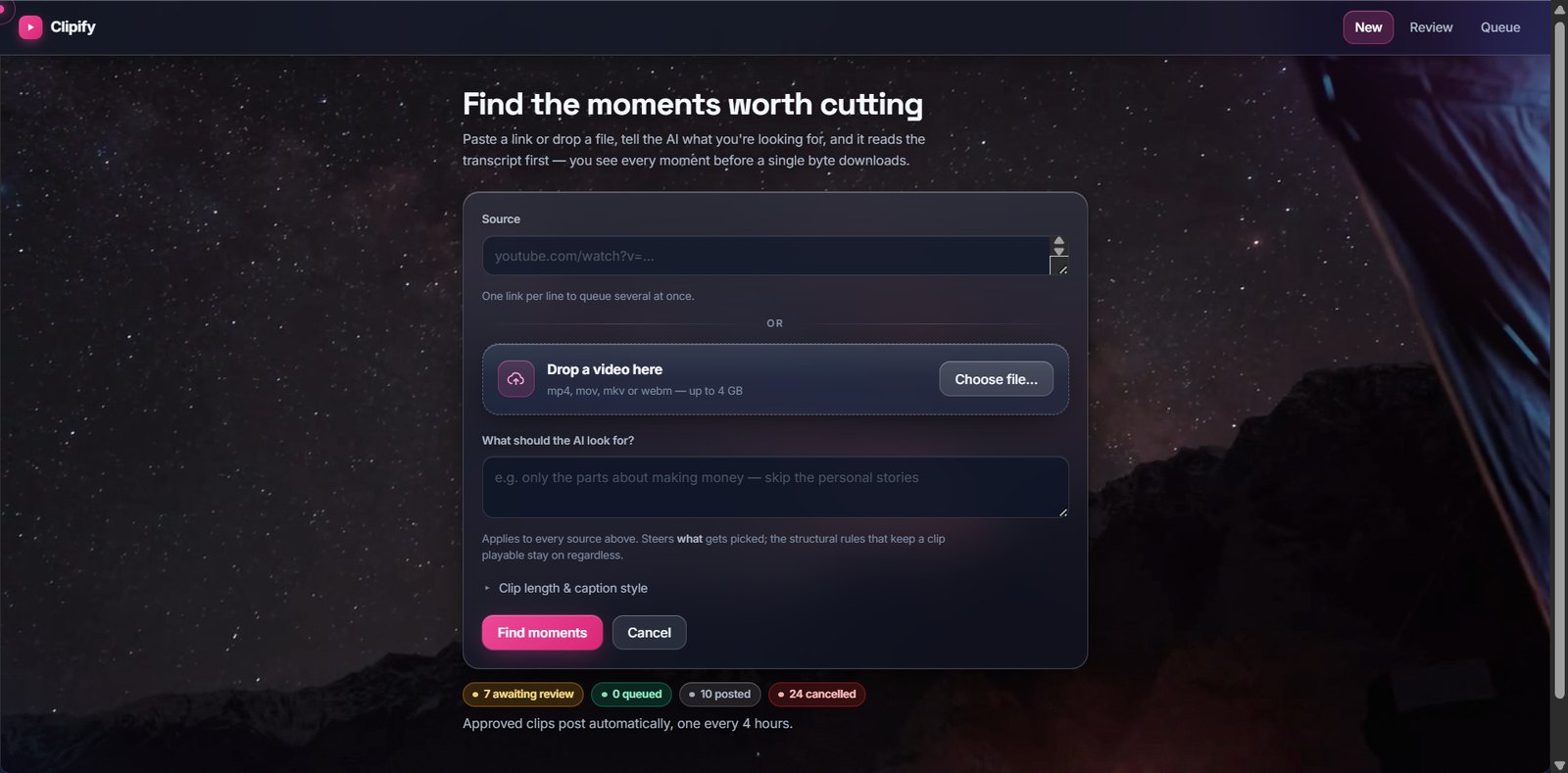
Clipify interface: paste a link or drop a file and tell the AI what to look for, with review and queue navigation
Running

Clipify · clip factory

Long video into short form, without losing the veto

A full web app, not a script. Paste a link and it reads the transcript first, so every moment is visible before a single byte of video downloads. You tick what is worth making, it renders with word-level captions, you watch each result, and only then does anything publish.

Reading the transcript first is also what makes it cheap. The download is only the chosen window, about 5 MB instead of gigabytes, and further clips from the same source cost nothing but a render.

Per build
~5 MB
Human gates
2
Cadence
4 h

Python · Flask · FFmpeg · Whisper · vision and transcript models · SQLite

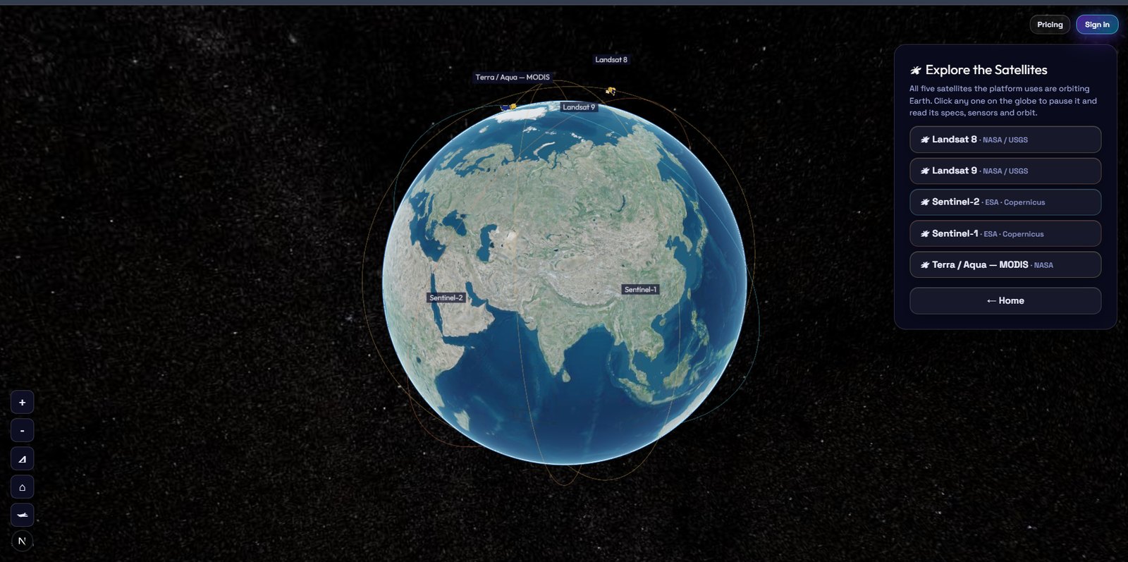
GeoReport AI: a 3D globe with five satellites in orbit and a panel listing Landsat 8, Landsat 9, Sentinel-2, Sentinel-1 and Terra Aqua MODIS
Live

GeoReport AI

Reports written from measurements, not guesses

Draw an area on a living globe, pick two periods, and get a change-detection report. The analysis runs first and the model only ever describes numbers it actually produced, so it can write the report but never invent the measurement.

Analyses
28
Turnaround
~10 min

FastAPI · Next.js · CesiumJS · Earth Engine · Sentinel · Landsat · MODIS

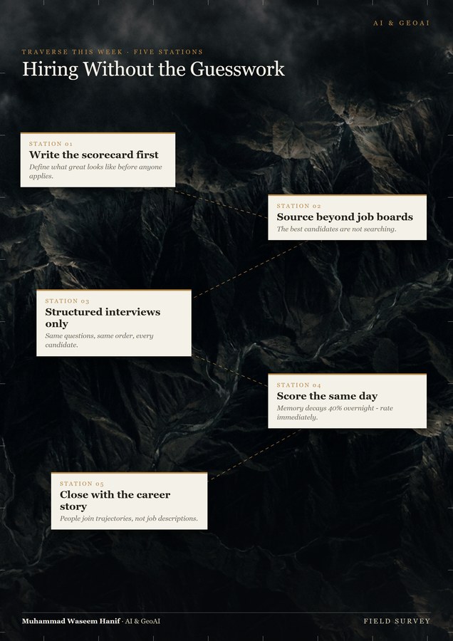
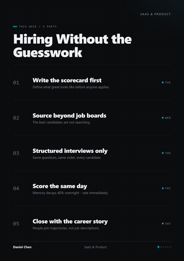
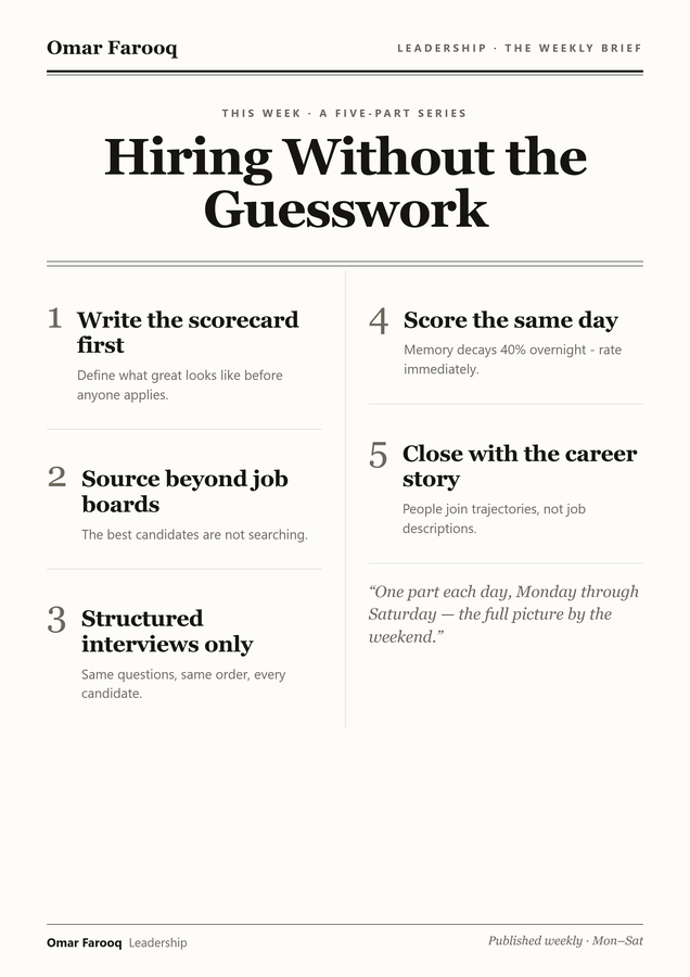
Generated poster in a cartographic theme Generated poster in a dark ledger theme Generated poster in a newspaper editorial theme
Running multi-client

Publishing engine · one approval per week

A weekly content engine with a real design system behind it

Every Sunday it plans a five-part series, renders six A4 posters and sends one email. Reply once to approve and it publishes the right poster each weekday without further input. A pillar rotation walks a twelve-topic sweep while a no-repeat memory keeps recent topics out of the prompt.

Those three are real output from roughly twenty-six themes across eight distinct layout architectures, not one skin recoloured eight times. It waits for the network, retries, guards against double-posting, and publishes the next unposted item rather than indexing on the weekday, so a missed day never drops a post.

Themes
~26
Architectures
8
Approvals
1 / wk

Python · LinkedIn UGC API · headless render · IMAP approval loop

More automation

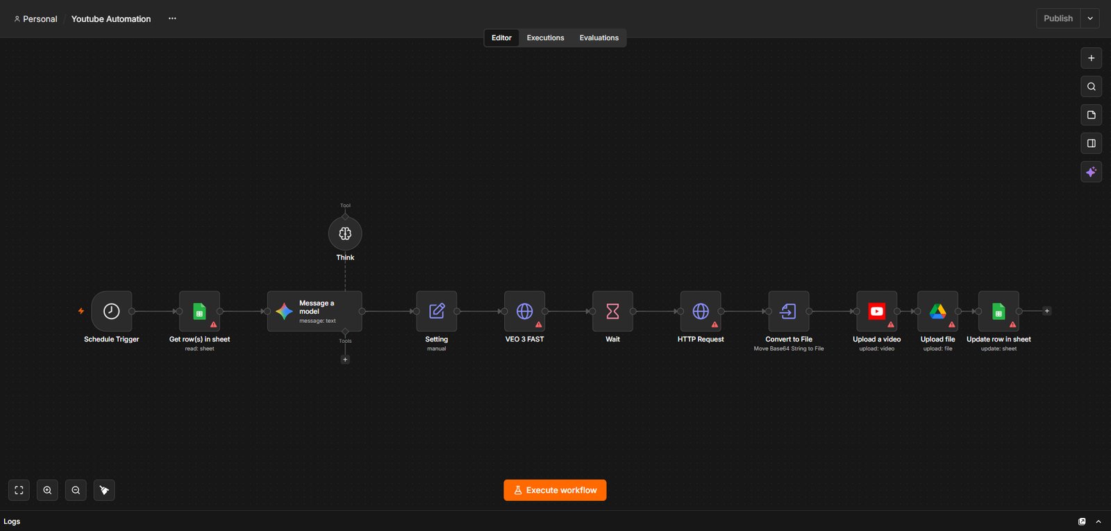
The Youtube Automation canvas in n8n: schedule trigger, sheet read, a model with a think tool, Veo 3 Fast, wait, convert, upload and sheet update

Text to published video

A scheduled pipeline reads a topic from a spreadsheet, has a model think through the treatment, generates the footage with Veo 3, uploads and publishes it, then writes the result back. Nobody touches it between topic and live video.

n8n · Gemini · Veo 3 Fast · Drive · Sheets

LeadGen Engine

Finds target businesses, reads each prospect’s site, writes a genuinely specific email rather than a template, and sends on a daily cap. Nothing leaves the machine until a person approves the draft. The engineering is in surviving unattended operation: dead connections reconnect rather than being misreported as bounces.

Python · Playwright · SQLite · SMTP and IMAP

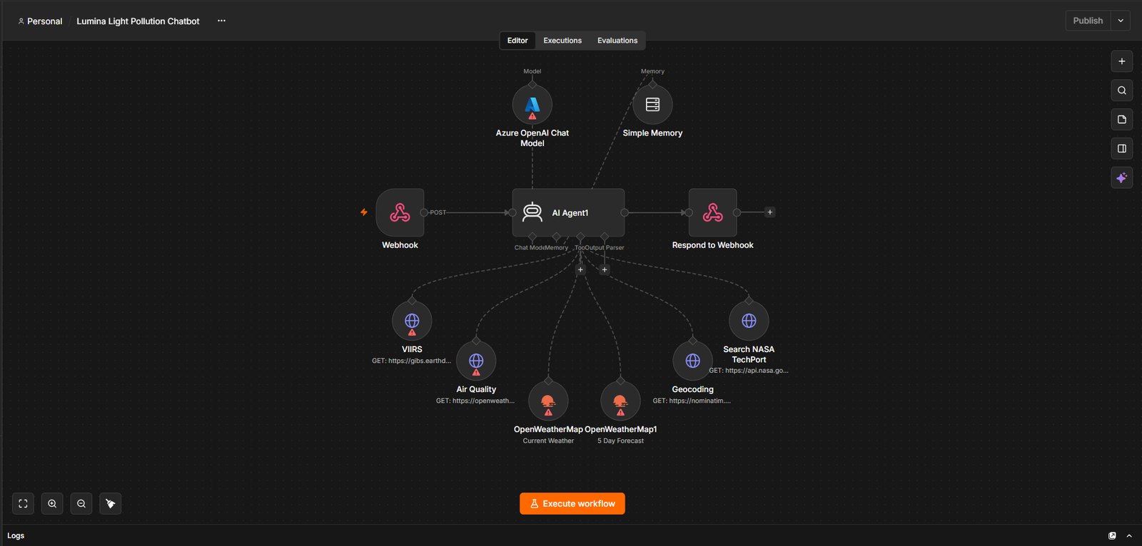
The Lumina canvas in n8n: an AI agent behind a webhook with six data tools including VIIRS, air quality, weather, geocoding and a NASA index

Lumina

A conversational agent for night-sky and air-quality questions, holding six live data tools: VIIRS radiance, geocoding, weather, air quality and a NASA research index. It fetches real measurements rather than recalling them.

n8n · Gemini · VIIRS · OpenWeatherMap. The WebGIS platform it plugs into is a third-party open-source template; the agent is mine.

StickMind

Fully original animation with no third-party footage anywhere. The part worth showing is the validation harness: it re-derives the inverse kinematics and asserts feet-on-floor, no-slide and no-inverted-shin across every frame of every action, which caught four bugs that had shipped in every previous video.

Remotion · React · Whisper · inverse kinematics · FFmpeg

Demo accounts only

Trading systems

Multi-book MetaTrader 5 architecture, each book isolated on an always-on VM. The value is the apparatus rather than the strategy: walk-forward backtesting with separate in-sample and out-of-sample windows, half-Kelly sizing with a drawdown governor, circuit breakers. Every AI veto is forward-simulated into a shadow book so the layer can be measured instead of assumed. No performance claim is made here.

Python · MetaTrader 5 · PyTorch · LightGBM · Azure VM

Tooling

architect-agent interviews you about a project idea, then generates the architecture document, sub-agents and task breakdown. A Shopify scraper extracts structured product data and feeds the video pipeline above. A Meta Ad Library scraper pulls competitor creative, still in progress.

Python · Flask · Playwright · Docker · private repositories, walkthrough on request

Where the rigour comes from

The measurement side.

Remote sensing is where I learned that a confident-looking output is worthless if the method behind it does not hold. That habit is what I bring to the AI work.

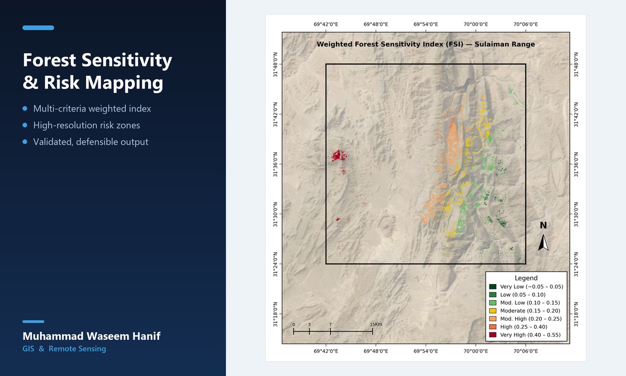
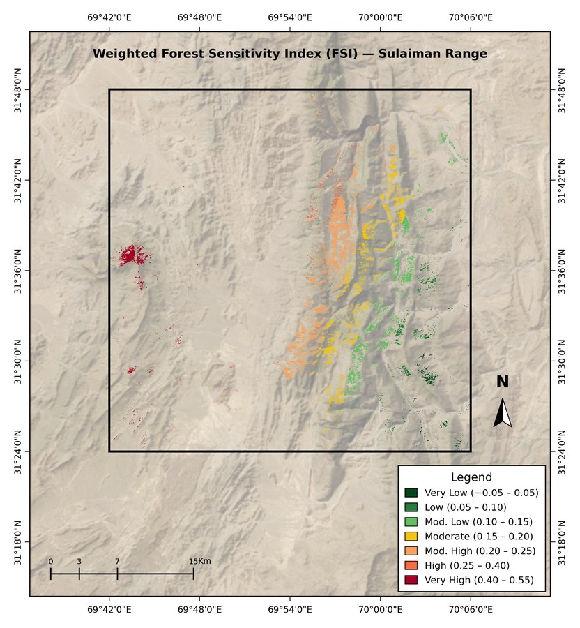
Weighted Forest Sensitivity Index map of the Sulaiman Range showing graduated risk classes over hillshaded terrain

Sulaiman Range, Pakistan

Climate-driven forest sensitivity from SAR and optical time series

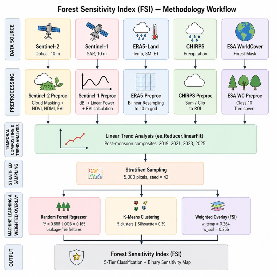
Four post-monsoon epochs of Sentinel-1 SAR and Sentinel-2 imagery, composited in Earth Engine and fused into a weighted five-tier sensitivity index. Random Forest carried the predictive step, and the index was validated against independent occurrence data rather than back-fitted to a desired answer.

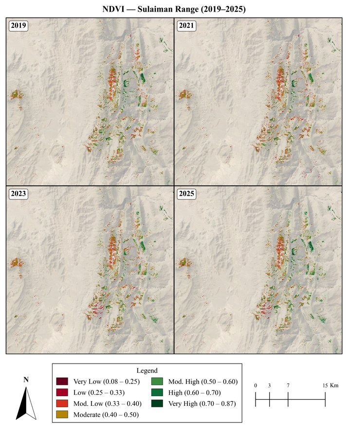
Across 2019 to 2025 NDVI rose 2.9 percent while soil moisture fell 40 percent and evapotranspiration fell 41 percent: greener canopy over a drying root zone.

0.8879
RMSE
0.00388
Pixel
10 m

Google Earth Engine · Sentinel-1 GRD · Sentinel-2 SR · Random Forest · QGIS
Pipeline source on GitHub

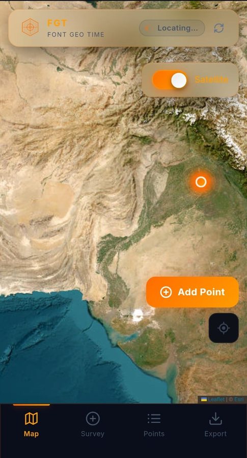
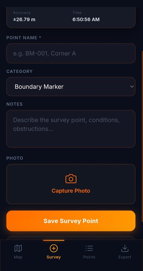
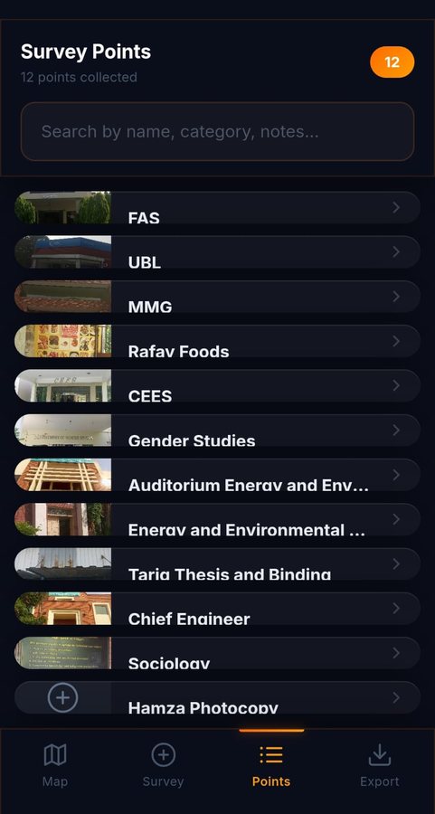
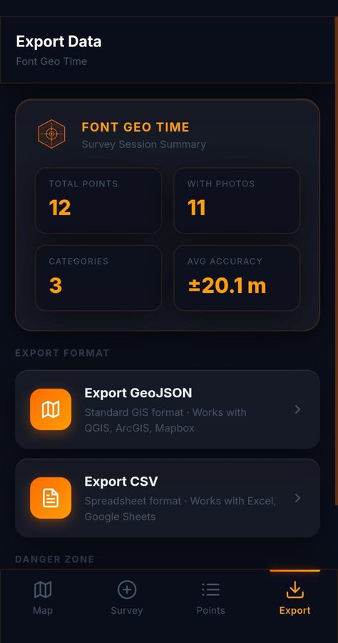
FGT map view with satellite basemap, a located position and an Add Point button FGT survey form with GPS accuracy, point name, category, notes and capture photo FGT points list showing twelve collected survey points with photo thumbnails FGT export screen with a session summary and GeoJSON or CSV export options
Shipped · Android and PWA

FGT · Font Geo Time

A field survey app for places with no signal

Points are captured with live GPS accuracy, a category, notes and a photo, held locally on the handset, then exported as GeoJSON or CSV once you are back in range. The export screen reports the session honestly: how many points, how many carry a photo, and the average accuracy, so you know what the data is worth before it reaches a desk.

Built offline-first because a surveyor loses signal exactly when the work happens. Shipped as a progressive web app and a native Android build, verified on a real handset across six released versions.

APK size
8.44 MB
Versions
6
Categories
12

React 18 · Vite · Leaflet · Capacitor 8 · IndexedDB · Workbox PWA · Esri imagery

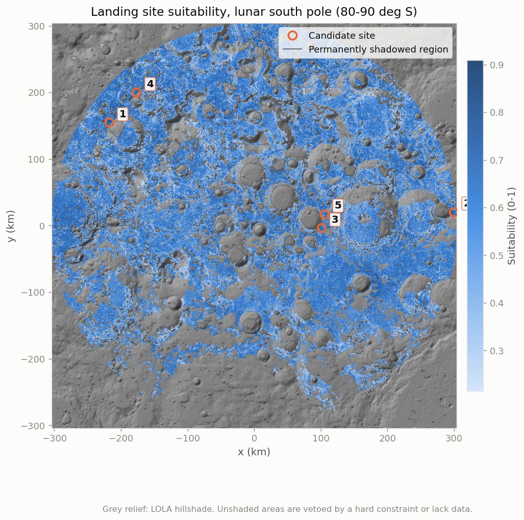
Landing site suitability map of the lunar south pole with numbered candidate sites over LOLA hillshade

Lunar south pole · 80 to 90°S

Artemis-class landing site screening

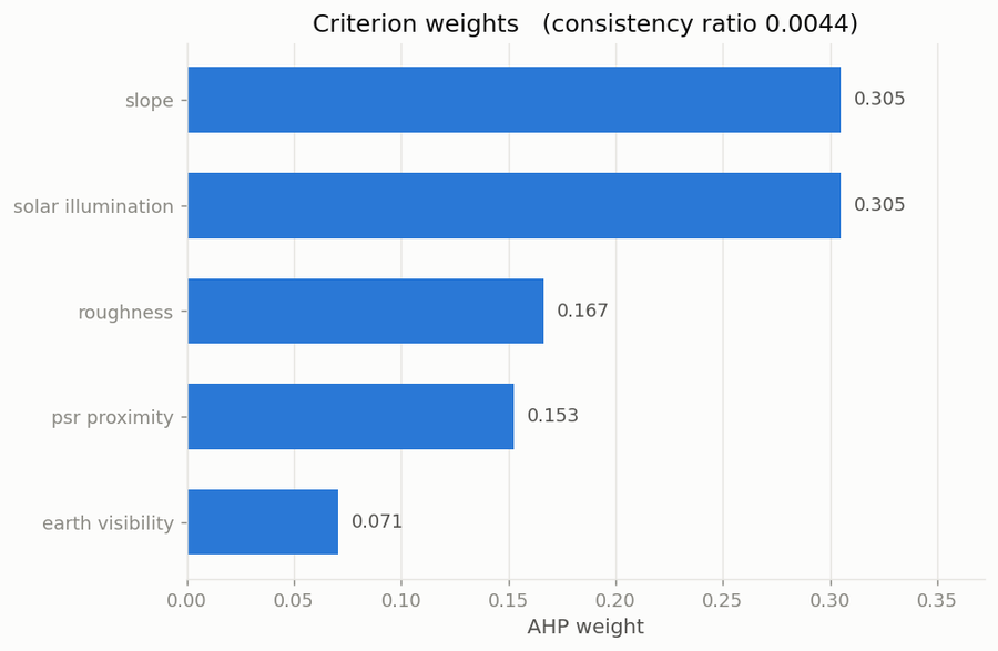
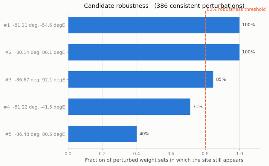
AHP-weighted fuzzy multi-criteria evaluation across NASA LOLA topography, illumination and roughness, with hard constraints vetoing unlandable terrain. The result was checked against an external benchmark rather than asserted: all nine NASA Artemis III candidate regions fall inside the top 0.1 percent of the scored surface.

Validation
9 / 9
Percentile
0.1 %
Grid
50 m

Python · rasterio · geopandas · scipy · NASA LOLA

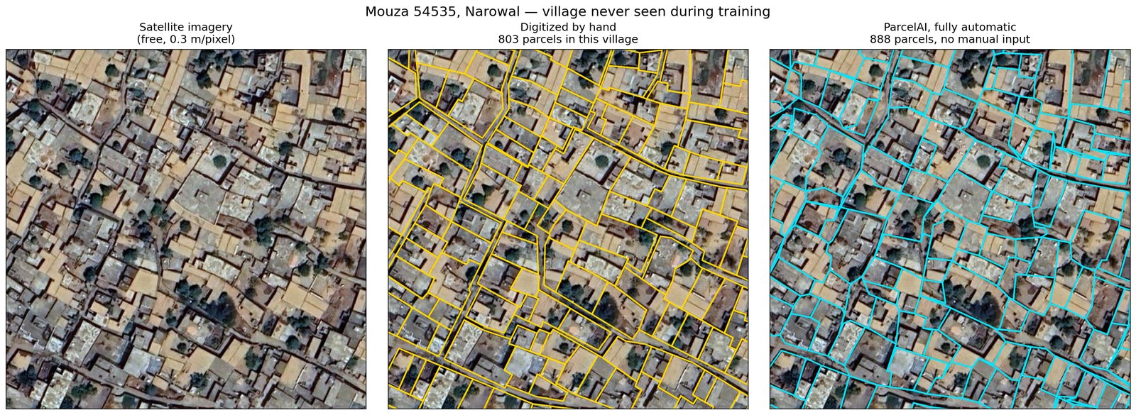
Reference cadastral parcel boundaries beside model-predicted boundaries for a village

ParcelAI · land record digitization

The honest limit that shaped the product

A multi-task U-Net trained on more than 20,000 real digitized parcels. Auto-accept tops out near 88 percent correct, so blind automation is not sellable and the project does not claim it. What is sellable is review order: worst-first review reaches 96 percent correctness at 70 percent of the effort, surfacing errors up to 2.5 times faster than random.

Parcel F1
0.689
Boundary F1
0.775
Tolerance
1.5 m

PyTorch · ONNX Runtime · MobileSAM · FastAPI · QGIS plugin

Weighted Forest Sensitivity Index map
Weighted FSISeven-class index, 10 m
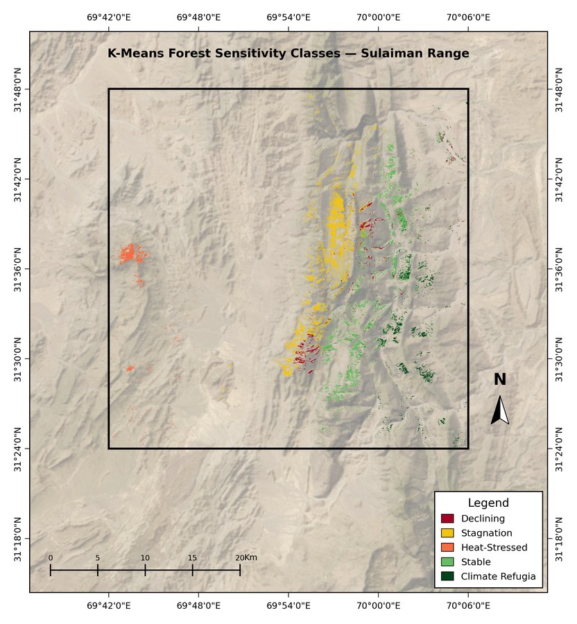
Five class K-Means classification map
K-MeansFive-class unsupervised
Multi-year NDVI composite panels
NDVI compositeFour epochs
Multi-year SAR radar vegetation index composite
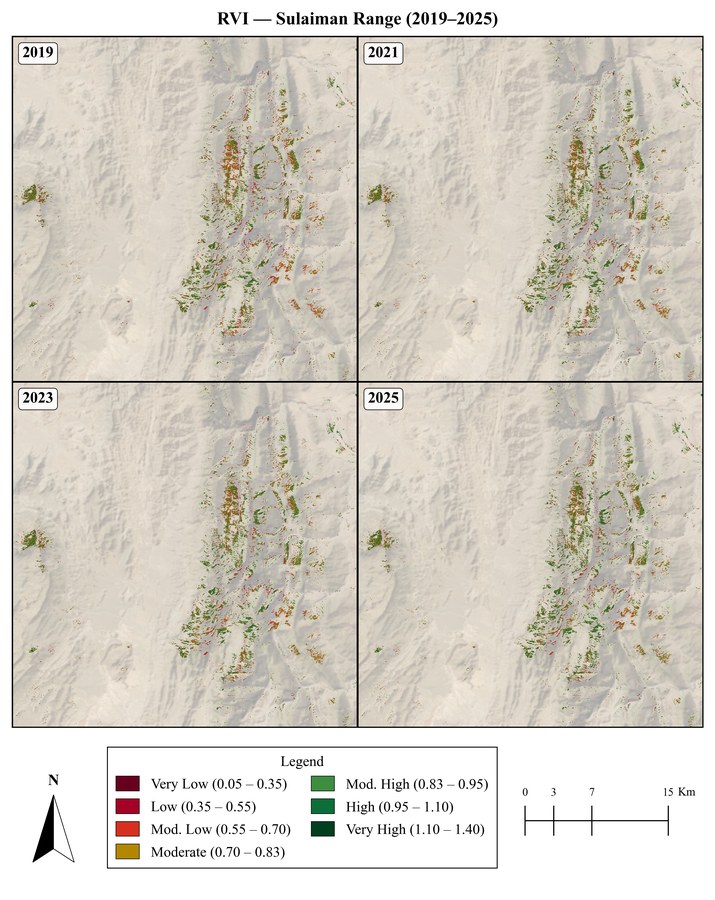
SAR RVIAll weather
Digital elevation model hillshade
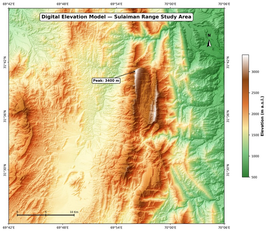
DEM hillshadeTerrain relief
Study area location map
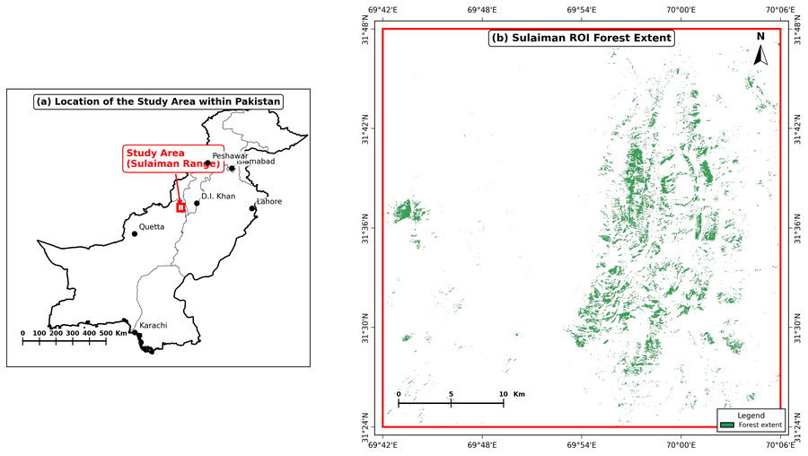
Study areaLocation and extent
Forest sensitivity index validation figure
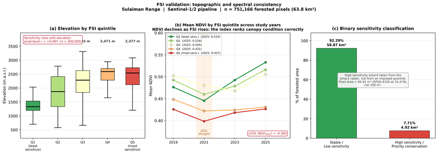
FSI validationOccurrence check
AHP criterion weights figure
AHP weightsCriterion weighting
Weight sensitivity analysis figure
SensitivityRanking stability
Methodology workflow diagram
MethodologyProcessing chain

Research

Three papers, at the stage
they actually are.

Acta Geophysica
Springer · first author

Climate-driven forest biodiversity sensitivity

Sentinel-1 SAR time series fused with Sentinel-2 multispectral imagery over the Sulaiman Range.

Drafted, awaiting supervisor approval. Not submitted, not under review.

Quaternary International
Elsevier · third author

Multi-decadal assessment of Minapin Glacier, Karakoram

Landsat 5, 7 and 8 across six late-summer epochs from 2000 to 2025: glacier and perennial snow extent, land surface temperature, NDSI and SRTM hypsometry.

Prepared for submission.

EnMAP mission
Imaging spectroscopy

Hyperspectral mapping of polymer-bearing surfaces over Lahore

Tasking proposal granted with a twelve-tile allocation and four observation requests filed across three seasonal windows. Detection validated on EnMAP and EMIT data.

Acquisition scheduled. Field validation pending.

How I work

What I will tell you
before you commit.

Generated output needs a gate

Anything that publishes on your behalf gets a human approval step wherever being wrong in public costs more than the review time does.

A model is not a measurement

Where numbers matter I compute them first and let the model describe them. It can write the report; it does not get to invent the figure.

Imagery has hard limits

Optical data is cloud-limited and Sentinel-2 is 10 m at best. If your dates or your level of detail are not achievable, I say so before you order.

Sometimes the answer is no

One of my own studies concluded the method did not work at that site, and said so. You are better served by that than by something convincing and wrong.

Tools

n8n / Python / Claude / Gemini / fal.ai / ElevenLabs / Veo / Whisper / Pinecone / FFmpeg / Remotion / Playwright / FastAPI / Flask / Next.js / React / PyTorch / ONNX / QGIS / Google Earth Engine / CesiumJS / Leaflet / rasterio / geopandas / SQLite / PostGIS / Docker

Tell me what should
run without you.

Describe the process you are doing by hand, or the area and dates you need measured. I will come back with what can be automated, what should stay under human approval, and what I would build, before either of us commits to anything.

LinkedIn